Greenrail Solutions Ltd Contact Details
About Greenrail Solutions Ltd
Specialists in Railway Surveys, Track Surveying, Railway Monitoring, Track Geometry, Level Crossing Surveys and Pway Engineering throughout the UK.
What Greenrail do...
Greenrail Solutions is a subsidiary to the Greenhatch Group of companies, offering over 30 years surveying experience across all geospatial disciplines.
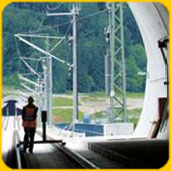
Our PTS trained staff specialise in Measured Building, Topographical, 3D Laser Scanning, Engineering and of course Railway Surveys. We combine experience with the very latest and most accurate equipment available to provide our clients with reliable deliverables everytime.
Through established and lasting relationships with our clients we exceed their expectations and gain their trust through exceptional performance by every member of our team.
How we can help you...
We offer the following services to the rail industry:
Greenrail Solutions Ltd feel that equipping ourselves with the latest and most accurate technologies available not only makes the deliverable to our clients reliable but makes the collection of the data more efficient.
This often reduces the time required to obtain the relevant information compared to more traditional methods reducing costs to our clients.
Please see below information on the technical equipment that we have invested in, if you would like any further information on workflows please contact us.
What Greenrail do...
Greenrail Solutions is a subsidiary to the Greenhatch Group of companies, offering over 30 years surveying experience across all geospatial disciplines.
Our PTS trained staff specialise in Measured Building, Topographical, 3D Laser Scanning, Engineering and of course Railway Surveys. We combine experience with the very latest and most accurate equipment available to provide our clients with reliable deliverables everytime.
Through established and lasting relationships with our clients we exceed their expectations and gain their trust through exceptional performance by every member of our team.
 |  |
How we can help you...
We offer the following services to the rail industry:
- Track geometry and gauging surveys
- Structure and tunnel profiling
- OHLE height and stagger surveys
- Level crossing surveys
- As built surveys
- Tramway surveys
- Survey and monitoring software
- HDS laser scanning surveys and data processing
- GPS linear control networks
- Fully automated and manual monitoring systems
- Non-contact surveying and remote monitoring
Greenrail Solutions Ltd feel that equipping ourselves with the latest and most accurate technologies available not only makes the deliverable to our clients reliable but makes the collection of the data more efficient.
This often reduces the time required to obtain the relevant information compared to more traditional methods reducing costs to our clients.
Please see below information on the technical equipment that we have invested in, if you would like any further information on workflows please contact us.
 | Leica TPS1200+ These robotic total stations are an integral part to all our Survey and Engineering works from controlling and maintaining our traverse networks to positioning the Amerg Trollies. |
 | Leica GNSS1200+ GPS/GNSS systems are being used more and more in the Rail Industry as an accurate tool for establishing and checking long, linear traverses. |
 | Leica DNA03 The most accurate digital level available from Leica Geosystems is used by our Surveyors to establish datum marks throughout the working corridor. They are also used to control the level of our traverse networks. |
 | Leica HDS6000 The Leica HDS6000 is the industry's most popular phase-based scanner allowing our surveyors the advantage of ultra high-speed, phase-based laser scanning. The HDS600 can scan up to 508,000 points per second and work in bright conditions or complete darkness enabling the HDS600 to scan objects in tunnels or at night that could easily be invisible to the human eye. |
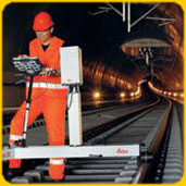
 | Amberg GRP1000 The Amberg GRP1000 rail trolley combined with the Leica TPS1200+ total station enables us to gain millimetre geometry of the track giving us all Chainage, Gauge, Super Elevation and 3D Track Co-ordinate information in real-time. More traditional track survey methods require the information collected to be post-processed adding cost and more importantly time to the project. |
 | Amberg GRP5000 The Amberg GRP5000 rail Trolley is a combination of the above GRP1000 and the Leica HDS6000 Laser scanner. In addition to measuring track geometry this trolley profiles tunnels, structures and OHLE for ''Clearance Surveys''. |
 UK
UK Ireland
 Scotland
 London


